DEPRECATION WARNING
This documentation is not using the current rendering mechanism and is probably outdated. The extension maintainer should switch to the new system. Details on how to use the rendering mechanism can be found here.
EXT: Extends tt_news with FE-User Editing
| Author: | Kasper Skårhøj |
|---|---|
| Created: | 2002-11-01T00:32:00 |
| Changed by: | anton schmidt |
| Changed: | 2010-01-11T10:30:14 |
| Author: | |
| Email: | typo3dev@geithware.de |
| Info 3: | |
| Info 4: |
EXT: Google Maps for tt_news
Extension Key: jf_easymaps
Copyright 2000-2005, , julian.fries.3000@googlemail.com <julian.fries.3000@googlemail.com>
This document is published under the Open Content License
available from http://www.opencontent.org/opl.shtml
The content of this document is related to TYPO3
- a GNU/GPL CMS/Framework available from www.typo3.com
Table of Contents
EXT: Google Maps for tt_news
Introduction 1
What does it do? 1
Users manual 2
Installation 2
Configuration 2
Administration 2
Introduction
What does it do?
Features
- FE-Users/BE-Users may add Google Maps to a selected news record easily
- No Geo-Codes needed, maps are simply displayed by filling required fields within a news record with just the real names of street, city and country
- Further possible configurations for a single news record: Type of map, map-height and display of infowindow
- There are additional configuration options for site-administrators, which are available in the backend via Flexform. These configurations are global, they apply for any news record
Users manual
Installation
- Install the extension with the extension manager.
- Go to the site in your pagetree, which holds the singleview-plugin of tt_news.
- Create new record and choose 'Google Maps for tt_news'
- Place your Google Maps api key in the field 'Api key'. If You dont have such key yet, go to http://code.google.com/intl/de- DE/apis/maps/signup.html and register a new key for your site.
- You may now use Google Maps within your news records.
Configuration
- In order to add a Google map to a news record You need to fill the fields tx_jfeasymaps_street, tx_jfeasymaps_city and tx_jfeasymaps_land at least. tx_jfeasymaps_city must be filled with name of the city and ZIP, for example 'Berlin10243'.
- For changing type of map, change field 'tx_jfeasymaps_type' to 1 (satelite) or 2 (hybrid).
- The Infowindow wont be shown, unless you havent filled 'tx_jfeasymaps_infofenster' with text.
- You may add these data via html-formular in the frontend, which is very easy with this extension, as you can use real names instead of geo-codes, whose concept might be unknown to fe_users of a site.
- If You want to fill out these fields in the BE, you may do this within phpmyadmin, which is available as TYPO3 extension in the TER. You can also fill in the data in a tt_news record in the BE, though i have not added any labels to these fields yet, so you might guess, which is the right field.
Administration
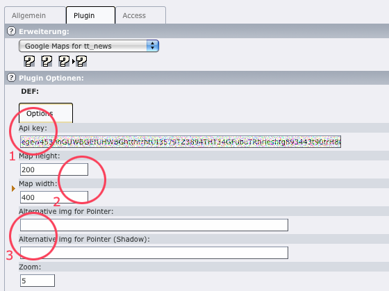
Have a look at the following screenshot, which shows config-options for the admin. For having the Extension working, you just need to fill the field Api key (1). The other fields can just left empty.
Please consider, that no pointer will be rendered, if you fill the img-fields (2) with invalid value. By leaving it empty, default imgs will be shown. As in my opinion in most applications the need for flexible height will be more important then width, which mostly goes about whole scale of a column, it is possible for the fe_user to change height of a single map, but not width. Both values (3) can be configured in the flexform, the height value will be overwritten though, if the fe_user changes the value in the record.
 EXT: Google Maps for tt_news - 3