---
title: "Administration"
version: "4.3"
source: "Administrators/Index.rst"
rendered: "2026-10-01T21:53:50+00:00"
---
# Administration {#administration}
## Extension Configuration {#extension-configuration}
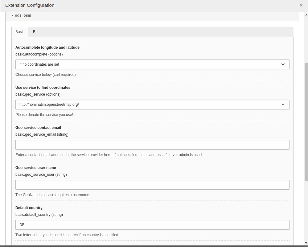
Some global settings of the extension may be configured in `Settings -> Extension Configuration -> ods_osm`.
### Screenshot {#screenshot}
### Reference {#reference}
| Option | Description | Default |
| --- | --- | --- |
| Autocomplete longitude and latitude | You can enable to search the coordinates on geonames.org when saving an fe_users or tt_address element. | 1: If no coordinates are set |
| Use service to find coordinates | Use this service to get the coordinates of an address. If you select “Only cache” you have to fill the cache table manually. If you select a provider here, be aware that the fields “zip”, “city” and “country” of every address record you save is sent to the provider. | 2: Nominatim |
| Geo service contact email | Enter a contact email address for the service provider here. If not specified, email address of server admin is used. | |
| Geo service user name | The GeoNames service requires a username | |
| Default country | Two letter countrycode used in search if no country is specified. | DE |
| Enable address search cache | The result of the geo service is stored in tx_odsosm_geocache if activated. | 1 |
| Use local javascripts and images | Activate this if you don't like to use the javascript files from CDNs but the local ones from this extension. | 1 |
| Default longitude | | 10.41 |
| Default latitude | | 51.27 |
| Default zoom | | 8 |
## TypoScript Configuration {#typoscript-configuration}
It is mandatory to include the ods_osm TypoScript template "Template OpenStreetMap".
This template sets some default values for the ods_osm plugin. The defaults may be configured
with the TypoScript Constant Editor.
With these TypoScript defaults, the editor does not need to make a detailed configuration of the
ods_osm plugin. Selecting the wanted marker is suffician.
The dimenions of the map, the right JavaScript library and zoom level are set by the defaults.
But editors may set and overwrite the defaults in the plugin settings.
### Reference {#reference-1}
| Property | Data type | Description | Default |
| --- | --- | --- | --- |
| cluster | boolean | Cluster marker at lower map zoom. | 0 |
| cluster_radius | integer | Cluster marker in given radius. | 80 |
| external_control | boolean | Allow control with GET or POST\ lon: Map center longitude\ lat: Map center latitudezoom: Map zoom level\ layers: Comma separated list of tx_odsosm_layer uid's\ records: Comma separated list of markers\ Don't forget to set no_cache=1 | 0 |
| height | integer | Height of the map div block. This depends on your webdesign. The default value is 80vh which means 80% from current view port. You can set other values like "80%", 480, 480px | 80vh |
| icon | IMAGE or TEXT object | Default marker image | Library default |
| JSlibrary | string | JavaScript library: none / jquery | none |
| layer | integer list | \| Comma separated list of tx_odsosm_layer uid's. \| 1: Mapnik \| 2: SLUB Renderer \| 3: CycleMap \| 13: ÖPNV Deutschland \| 14: Hike & Bike Map \| 15: Hillshading (NASA SRTM3 v2) \| 17: Hiking routes \| 18: Mapnik BW \| 19: MapSurfer.Net Road \| 20: MapSurfer.Net Topographic \| 21: MapSurfer.Net Hybrid \| 25: TransportMap \| 28: Cycling routes \| 29: Stamen Toner \| 30: Stamen Watercolor \| 31: Public Transport Lines \| 32: Stamen Terrain Labels \| 33: Railway Infrastructure | 1 |
| library | string | Library: leaflet / openlayers / openlayers3 / static | ol |
| marker | array with table name and integer list | Tablenames and a comma separated list of record ids. | see [m](#m) |
| mpi | integer | Open popup of this marker | |
| no_marker | boolean | If no marker is set:\ 0: Hide map\ 1: Show map | 1 |
| popup | TS object | There are two additional fields: “group_title” and “group_description” filled with group information. | see [p](#p) |
| position | boolean | Get current user postion from browser to center the map. | 0 |
| sls | boolean | | 0 |
| show_popups | boolean | 0:No\ 1:Click\ 2:Hover | 0 |
| show_scalebar | boolean | Show a scale line on the map. | 0 |
| uconm | boolean | Use the default coordinates only if no marker exists. | 0 |
| width | integer | Height of the map div block. This depends on your webdesign. The default value is 80vw which means 80% from current view port. You can set other values like "100%", 640, 640px | 80vw |
### Examples {#examples}
```
plugin.tx_odsosm_pi1 {
width = 800
height = 600
mouse_position = 1
}
```
#### Markers {#m}
```typoscript
plugin.tx_odsosm_pi1 {
marker {
pages =
fe_users =
fe_groups =
tx_odsosm_track =
}
}
```
#### Popups {#p}
```typoscript
plugin.tx_odsosm_pi1 {
popup {
fe_users = COA
fe_users {
9 = FILES
9 {
references {
table = fe_users
fieldName = image
}
renderObj = IMAGE
renderObj {
file {
import.data = file:current:uid
treatIdAsReference = 1
width = 150c
height = 150c
}
altText.data = file:current:alternative
titleText.data = file:current:title
stdWrap.typolink.parameter.data = file:current:link
}
}
10 = TEXT
10 {
field = name
wrap = |
override = {field:first_name} {field:middle_name} {field:last_name}
override.insertData = 1
override.if.isFalse.field = name
}
20 = TEXT
20.field = description
20.htmlSpecialChars = 1
}
tt_address = COA
tt_address {
9 = FILES
9 {
references {
table = tt_address
fieldName = image
}
renderObj = IMAGE
renderObj {
file {
import.data = file:current:uid
treatIdAsReference = 1
width = 150c
height = 150c
}
altText.data = file:current:alternative
titleText.data = file:current:title
stdWrap.typolink.parameter.data = file:current:link
}
}
10 = TEXT
10.field = name
10.wrap = |
20 = TEXT
20.field = description
20.stdWrap.parseFunc < lib.parseFunc_RTE
20.htmlSpecialChars = 0
}
}
}
```
#### Icon Property {#icon-property}
```typoscript
plugin.tx_odsosm_pi1 {
icon {
# IMAGE example
fe_users = IMAGE
fe_users {
file = fileadmin/icon.png
file.width = 60px
}
# HTML example
fe_users = TEXT
fe_users {
value = X
size_x=20
size_y=30
offset_x=10
offset_y=15
}
}
}
```