DEPRECATION WARNING
This documentation is not using the current rendering mechanism and is probably outdated. The extension maintainer should switch to the new system. Details on how to use the rendering mechanism can be found here.
EXT: pitgoogleforecast
| Created: | 2009-11-06T15:16:44 |
|---|---|
| Changed: | 2010-01-25T17:16:48 |
| Classification: | pitgoogleforecast |
| Description: | This extension is used to display google forecast weather details. In the backend, the user have to configure the location code and language code to display it in frontend. |
| Keywords: | weather, climate, forecast, google, api, pitsolutions |
| Author: | Ajesh M S |
| Email: | ajesh@pitsolutions.com |
| Info 4: | |
| Language: | en |

 -pit_googlemap
EXT: pit_googlemap
Extension Key: pit_googlemap
Language: en
Keywords: google, map, pitsolution
Copyright 2000-2010 Ajesh M S, <ajesh@pitsolutions.com>
This document is published under the Open Content License
available from http://www.opencontent.org/opl.shtml
The content of this document is related to TYPO3
- a GNU/GPL CMS/Framework available from www.typo3.org
Table of Contents
`Introduction 3 <#1.1.Introduction|outline>`_
`Users manual 7 <#1.2.Users%20manual|outline>`_
`Configuration 8 <#1.3.Configuration|outline>`_
`Known problems 11 <#1.4.Known%20problems|outline>`_
`To-Do list 12 <#1.5.To-Do%20list|outline>`_
`ChangeLog 13 <#1.6.ChangeLog|outline>`_
Introduction
What does it do?
This extension is used to display events in a specified area with the help of google map. The extension allows to enter the events from the backend and frontend. Admin review is also possible for the frontend entry. Also detailed view of each event is possible using this extension. The events can be categorized into regions based on there geographical location. The plugin provides option to filter events based on region in the map. The event markers are loaded dynamically from xml on each mouse drag or click in the map. This is ideally suited when there are a lot of markers to be marked on the map.
Screenshots
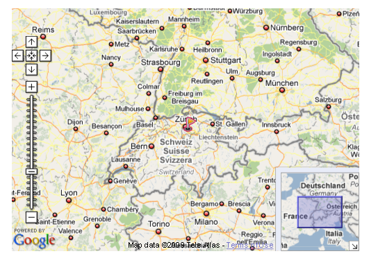
Showing region.
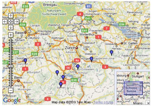
Showing cluster of events added in a region.
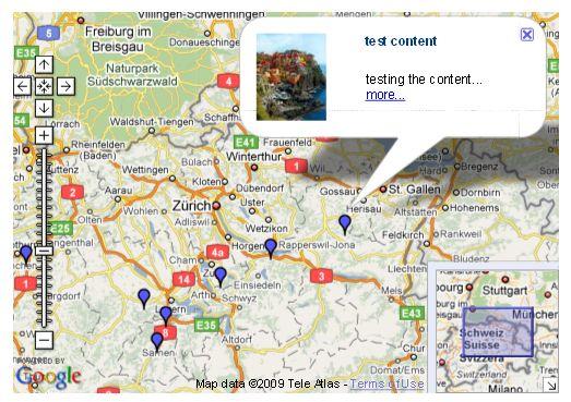
Showing information of events in a popup.
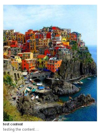
Showing detailed information of events.
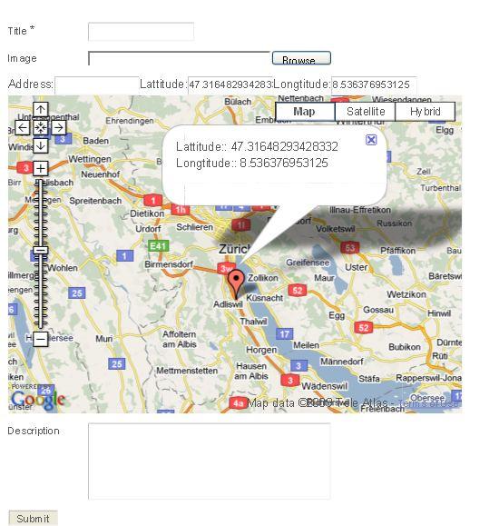
 Showing event entry form in the frontend.
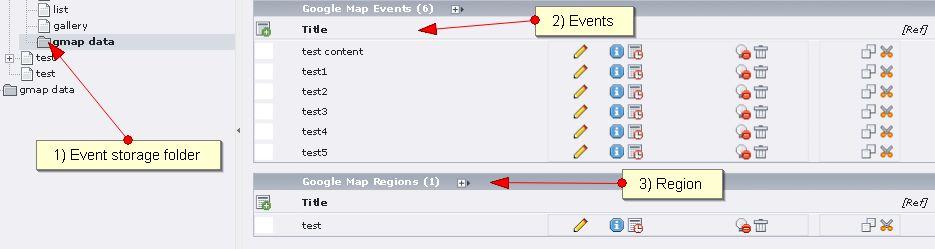
Showing events and regions listing from the backend.
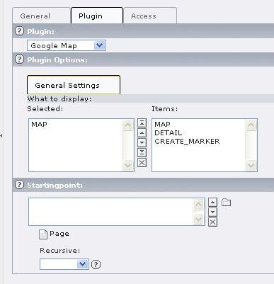
Showing item selection from the backend.
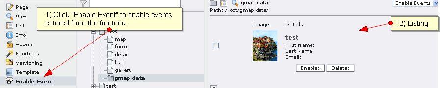
Showing enable event from the backend.
Users manual
Just install it from the online repository. Go to a page, change it's type to „Insert Plugin“ and insert the plugin „Google Map“. Select items to display. Three options are there „MAP“, „DETAIL“ and „CREATE_MARKER“.
Configuration
Reference
Possible subsections: Reference (TypoScript)
general
templateFile
Property
templateFile
Data type
string
Description
Sets the path to the template file
Default
template.info = EXT:pit_googlemap/res/info.tmpl
templateFile
Property
templateFile
Data type
string
Description
Sets the path to the template file
Default
template.form = EXT:pit_googlemap/res/form.tmpl
templateFile
Property
templateFile
Data type
string
Description
Sets the path to the template file
Default
template.detail = EXT:pit_googlemap/res/detail.tmpl
XML generation
Property
XML generation
Data type
stdWrap
Description
Sets xml configurations for regions and events for google map.
Default
# dynamically generate xml for events and region markers in google map
[globalVar = TSFE:type = 103]
plugin.tx_pitgooglemap_pi1.display=XML
[global]
xmlmap = PAGE
xmlmap.typeNum = 103
xmlmap {
config.index_enable = 0
config.disableAllHeaderCode = 1
config.additionalHeaders = Content-type:text/xml
no_cache = 1
xhtml_cleaning = 0
10 < plugin.tx_pitgooglemap_pi1
}
info
Property
info
Data type
stdWrap
Description
Sets maximum width and height of image in info page.
Default
# set width and height
plugin.tx_pitgooglemap_pi1.info {
image {
maxW = 80
maxH = 80
}
}
detail
Property
detail
Data type
stdWrap
Description
Sets maximum width and height of image in detail page.
Default
# set width and height
plugin.tx_pitgooglemap_pi1.detail {
image {
maxW = 500
maxH = 400
}
}
storagePid
Property
storagePid
Data type
Description
Sets page id of storage folder.
Default
plugin.tx_pitgooglemap_pi1.storagePid = 42
recursive
Property
recursive
Data type
Description
Sets enabled to get all the storage folder.
Default
plugin.tx_pitgooglemap_pi1.recursive = 1
xml
Property
xml
Data type
Description
Sets xml type number.
Default
plugin.tx_pitgooglemap_pi1.xml.typenum=103
apiKey
Property
apiKey
Data type
Description
Sets API key generated from google for the website
Default
plugin.tx_pitgooglemap_pi1.apiKey = http://yoursite.com |google api key
eg: plugin.tx_pitgooglemap_pi1.apiKey = http://192.168.0.5 |ABQIAAAA-GpUuDbZHbjlx5dZRf8JnRT9BDtxsQ5EhUnmuzmvHQoCWi- qFxQ6peQNGUsKLbDGBcjumDjR4wZDXA
defaultLatLng
Property
defaultLatLng
Data type
Description
Sets default latitude and longitude
Default
plugin.tx_pitgooglemap_pi1.defaultLatLng = 8.503696|76.952187
obligationfields
Property
obligationfields
Data type
Description
Sets required field
Default
plugin.tx_pitgooglemap_pi1.obligationfields = title
obligationfieldcharacter
Property
obligationfieldcharacter
Data type
Description
Sets identifier for mandatory fields
Default
plugin.tx_pitgooglemap_pi1.obligationfieldcharacter = *
pid_list
Property
pid_list
Data type
Description
Sets page id of form display
Default
plugin.tx_pitgooglemap_pi1.pid_list = 22
redirect_page
Property
redirect_page
Data type
Description
Sets page id of redirection after form submit
Default
plugin.tx_pitgooglemap_pi1.redirect_page = 22
pid_detail
Property
pid_detail
Data type
Description
Sets page id of detailed view
Default
plugin.tx_pitgooglemap_pi1.pid_detail = 21
manual_backend_release
Property
manual_backend_release
Data type
Description
If set 1 then the events added from the frontend needs admin confirmation to display in the site
Default
plugin.tx_pitgooglemap_pi1.manual_backend_release = 1
map
defaultLat
Property
defaultLat
Data type
string
Description
Sets default latitude value the map has to be centered at
Default
plugin.tx_pitgooglemap_pi1.map.defaultLat = 8.503696
defaultLng
Property
defaultLng
Data type
string
Description
Sets default longitude value the map has to be centered at
Default
plugin.tx_pitgooglemap_pi1.map.defaultLng = 76.952187
defaultZoom
Property
defaultZoom
Data type
string
Description
Sets default zoom level for the map
Default
plugin.tx_pitgooglemap_pi1.map.defaultZoom = 6
zoomControlX
Property
zoomControlX
Data type
stdWrap
Description
Sets x cordinate of zoom controller.
Default
plugin.tx_pitgooglemap_pi1.map.zoomControlX = 0
zoomControlY
Property
zoomControlY
Data type
stdWrap
Description
Sets y cordinate of zoom controller.
Default
plugin.tx_pitgooglemap_pi1.map.zoomControlY = 40
mapW
Property
mapW
Data type
Description
Sets width of map.
Default
plugin.tx_pitgooglemap_pi1.map.mapW = 500
mapH
Property
mapH
Data type
Description
Sets height of map.
Default
plugin.tx_pitgooglemap_pi1.map.mapH = 350
mapID
Property
mapID
Data type
Description
Sets id of map
Default
plugin.tx_pitgooglemap_pi1.map.mapID = map
event.icon_path
Property
event.icon_path
Data type
Description
Sets path of the event icon file
Default
plugin.tx_pitgooglemap_pi1.map.event.icon_path = EXT:pit_googlemap/icons/mm_20_blue.png
event.anchor_position
Property
event.anchor_position
Data type
Description
Sets the x and y cordinate of the event point relative to the icon
Default
plugin.tx_pitgooglemap_pi1.map.event.anchor_position = 6,20
event.info_position
Property
event.info_position
Data type
Description
Sets the x and y cordinate of the info window relative to the icon
Default
plugin.tx_pitgooglemap_pi1.map.event.info_position = 6,1
event.zoom_start
Property
event.zoom_start
Data type
Description
Sets starting zoom level for events to be shown
Default
plugin.tx_pitgooglemap_pi1.map.event.zoom_start = 8
region.icon_path
Property
region.icon_path
Data type
Description
Sets path of the region icon file
Default
plugin.tx_pitgooglemap_pi1.map.region.icon_path = EXT:pit_googlemap/icons/region.png
region.anchor_position
Property
region.anchor_position
Data type
Description
Sets the x and y cordinate of the region point relative to the icon
Default
plugin.tx_pitgooglemap_pi1.map.region.anchor_position = 12,12
region.zoom_start
Property
region.zoom_start
Data type
Description
Sets starting zoom level for regions to be shown
Default
plugin.tx_pitgooglemap_pi1.map.region.zoom_start = 4
region.zoom_end
Property
region.zoom_end
Data type
Description
Sets ending zoom level for regions to be shown
Default
plugin.tx_pitgooglemap_pi1.map.region.zoom_end = 7
form
defaultLat
Property
defaultLat
Data type
string
Description
Sets default latitude value the map has to be centered at
Default
plugin.tx_pitgooglemap_pi1.form.defaultLat = 8.503696
defaultLng
Property
defaultLng
Data type
string
Description
Sets default longitude value the map has to be centered at
Default
plugin.tx_pitgooglemap_pi1.form.defaultLng = 76.952187
defaultZoom
Property
defaultZoom
Data type
string
Description
Sets default zoom level for the map
Default
plugin.tx_pitgooglemap_pi1.form.defaultZoom = 10
mapW
Property
mapW
Data type
Description
Sets width of map.
Default
plugin.tx_pitgooglemap_pi1.form.mapW = 500
mapH
Property
mapH
Data type
Description
Sets height of map.
Default
plugin.tx_pitgooglemap_pi1.form.mapH = 350
mapID
Property
mapID
Data type
Description
Sets id of map
Default
plugin.tx_pitgooglemap_pi1.form.mapID = map_canvas
Known problems
none
To-Do list
nothing