DEPRECATION WARNING
This documentation is not using the current rendering mechanism and is probably outdated. The extension maintainer should switch to the new system. Details on how to use the rendering mechanism can be found here.
EXT: Map24 Ajax Router
| Author: | Kasper Skårhøj |
|---|---|
| Created: | 2002-11-01T00:32:00 |
| Changed by: | Axel Klarmann |
| Changed: | 2007-08-20T15:18:36 |
| Email: | klarmann@zwo-null.de |
| Info 2: | Axel Klarmann |
| Info 3: | |
| Info 4: |
EXT: Map24 Ajax Router
((generated))
Table of Contents
Copyright 2
Introduction 3
What does it do? 3
Requirements 3
Configuration 4
Installing the extension 4
Setup 4
Usage 6
Known Problems/To-Do List 8
Change Log 9
Copyright
Extension Key: zn_map24ajax
Copyright 2007, Axel Klarmann, <klarmann(at)zwo-null.de>
This document is published under the Open Content Licenseavailable from http://www.opencontent.org/opl.shtml
The content of this document is related to TYPO3a GNU/GPL CMS/Framework available from www.typo3.com
The images that are shown as examples are allcopyright © 2007 Mapsolute, NAVTEQ, Europa Technologies anddo not fall under the open content license.
Introduction
What does it do?
This Extensions enables the use of the Map24 ( www.map24.de ) routing an mapping service. It allows you to show a location with your own icon. Furthermore the display ist prepended with some inputfiedls, where the user may enter his address to calculate the route to the target address given by the siteowner.
Requirements
Extension Map24 - Ajax Router (extension key: zn_map24ajax ) requires TYPO3 4.0.0+ and PHP 4.1.0+.
You will need a map24 account ( http://devnet.map24.com/ as of August 2007) and have to set up an application key for your application ( http://devnet.map24.com/map24 -ajax-api/ajax_free_register as of August 2007)
Configuration
Installing the extension
Download an install the extensions as usual, using the extension manager.
It doesn't depend on other extension and it won't create any new tables, nor does it change existing tables. The extension will be available as frontend plugin.
Setup
The extension doesn't use any typoscript configuration. All parameters are set up using the extension backend interface.
The extension currently is only configurable in german, the english backend will follow on request.
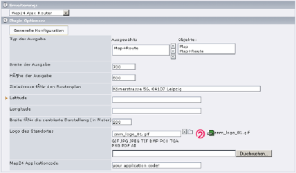
„Typ der Ausgabe“ selects the output of the extension. If you choose „Map“ only the map will be displayed. The routing information are not shown. If you choose „Map+Route“ the output of the map ist prepended with two fields that allows the user to enter his location information, and appended with an block, that will contain the routing information.
„Breite der Ausgabe“ determines the width of the output map in pixel. „Höhe der Ausgabe“ determines the height of the map in pixel, without the location fields and routing block.
„Zieladresse für den Routenplan“ determines the target the target of the routing as also the center of the map, when longitude and latttude are not set. The formatting depends on the map24-API, but you should go with street and housenumber first, followed by postal code and city name. The map will use the first item the map24-API returns on search for that address.
„Latitude“, „Longitude“ are specifying the center of the displayed region. The internal representation of the coordintates is based on WGS84. The following link explains the necessary calculations in detail: http://devnet.map24.com/manuals/doku.php?id=glossary:geograph iccoordinates If you use google maps to inquire the coordinates, you have to multiply the values with 60 (thanks to Mr. Kraemer for this hint).
„Breite für die zentrierte Darstellung“ allows you to set the region visible within the map. If you choose 200 mtrs., things in distance of 200 mtrs around the center of the map will be visible too. The map will be extended so that streets in the vicinity of 200 mtrs. will be shown.
„Logo des Standortes“ enables you to display an image located at the position determined by Latitude, Longitude or the address, when the coordinates are not given.
„Map24 Applicationcode“ have to be filled in with your application code the you gather from the map24 developer network.
Usage
The output of the plugin is shown below.
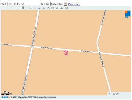
The map gives you all functions the map24-Applet has got, like enlarging a region of interest or moving the map around. Additionally the user is able to enter an adress in the field Start to calculate a rout from his location to the location given to the extension in the backend. By selecting the modus the user may choose the fastest or shortest route. By hitting the link Berechnen the route will be calculated. The map will contain the calculated routean shown underneath the map window.
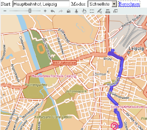
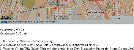
Underneath the map window the route description is embeded into the page.
Known Problems/To-Do List
If you have got some hints for further improvement, don't hesitate to contact me by mail.
Mostly the localisation needs updates. Improvements will be an english backend interface, maybe a grapical integration of coordinate selector and such.
 EXT: Map24 Ajax Router - 9