Administration
In the extension configuration
| Option | Description | Default |
|---|---|---|
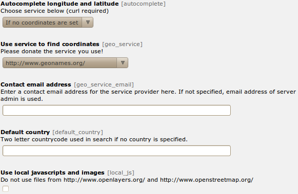
| Autocomplete longitude and latitude | You can enable to search the coordinates on geonames.org when saving an fe_users or tt_address element. | 1: If no coordinates are set |
| Use service to find coordinates | Use this service to get the coordinates of an address. If you select “Only cache” you have to fill the cache table manually. If you select a provider here, be aware that the fields “zip”, “city” and “country” of every address record you save is sent to the provider. | 2: Nominatim |
| Contact email address | Enter a contact email address for the service provider here. If not specified, email address of server admin is used. | |
| Use local javascripts and images | Activate this if you don’t like to use the javascript files from CDNs but the local ones from this extension. | 1 |
There is a function to mass gecode addresses in the functions menu.
Configuration
Reference
| Property | Data type | Description | Default |
|---|---|---|---|
| cluster | boolean | Cluster marker at lower map zoom. | 0 |
| cluster_radius | integer | Cluster marker in given radius. | 80 |
| external_control | boolean | Allow control with GET or POST
lon: Map center longitude
lat: Map center latitudezoom: Map
zoom level
layers: Comma separated list of
tx_odsosm_layer uid’s
records: Comma separated list of
markers
Don’t forget to set no_cache=1
|
0 |
| height | integer | 400 | |
| icon | IMAGE or TEXT object | Default marker image | Library default |
| JSlibrary | string | JavaScript library: none / jquery | none |
| layer | integer list | Comma separated list of
tx_odsosm_layer uid’s.
1: Mapnik
2: SLUB Renderer
3: CycleMap
13: ÖPNV Deutschland
14: Hike & Bike Map
15: Hillshading (NASA SRTM3 v2)
17: Hiking routes
18: Mapnik BW
19: MapSurfer.Net Road
20: MapSurfer.Net Topographic
21: MapSurfer.Net Hybrid
25: TransportMap
28: Cycling routes
29: Stamen Toner
30: Stamen Watercolor
31: Public Transport Lines
32: Stamen Terrain Labels
33: Railway Infrastructure
|
1 |
| layerswitcher. div | boolean | Use extra div for the layerswitcher. | 0 |
| layerswitcher. options | string | Additional options when creating layerswitcher. | |
| library | string | Library: leaflet / openlayers / openlayers3 / static | openlayers |
| marker | array with table name and integer list | Tablenames and a comma separated list of record ids. | see m |
| marker_popup_initial | integer | Open popup of this marker | |
| mouse_navigation | boolean | 0 | |
| no_marker | boolean | If no marker is set:
0: Hide map
1: Show map
|
1 |
| popup | TS object | There are two additional fields: “group_title” and “group_description” filled with group information. | see p |
| position | boolean | Get current user postion from browser to center the map. | 0 |
| show_layerswitcher | boolean | 0 | |
| show_pan_zoom | integer | 0:No
1:Bar
2:+/-
|
0 |
| show_popups | boolean | 0:No
1:Click
2:Hover
|
0 |
| show_scalebar | boolean | Show a scale line on the map. | 0 |
| static_script | string | Marker ###STATIC_SCRIPT### in layer “Include static JavaScript”. Use it for google or bing maps api key. | |
| use_coords_only_nomarker | boolean | Use the default coordinates only if no marker exists. | 0 |
| width | integer | 640 |
Examples
plugin.tx_odsosm_pi1 {
        width = 800
        height = 600
        mouse_navigation = 1
}
Markers
plugin.tx_odsosm_pi1 {
        marker {
                pages =
                fe_users =
                fe_groups =
                tx_odsosm_track =
        }
}
Popups
plugin.tx_odsosm_pi1 {
        popup {
                fe_users = COA
                fe_users {
                        10 = TEXT
                        10.field = name
                        10.wrap = <h2>|</h2>
                        20 = TEXT
                        20.field = description
                        20.htmlSpecialChars = 1
                }
                tt_address = COA
                tt_address {
                        10 = TEXT
                        10.field = name
                        10.wrap = <h2>|</h2>
                        20 = TEXT
                        20.field = description
                        20.htmlSpecialChars = 0
                }
        }
}
Icon Property
plugin.tx_odsosm_pi1 {
        icon {
                # IMAGE example
                fe_users = IMAGE
                fe_users {
                        file = fileadmin/icon.png
                        file.width = 60px
                }

                # HTML example
                fe_users = TEXT
                fe_users {
                        value = <span>X</span>
                        size_x=20
                        size_y=30
                        offset_x=10
                        offset_y=15
                }
        }
}