Users Manual
- The extension has to types of records: map and address.
- A map can have a plurality of addresses.
- Each frontend plug in includes one map.
- The records can be saved on every page. Preferred is an extra SysFolder.
- Each plugin requires one Map.
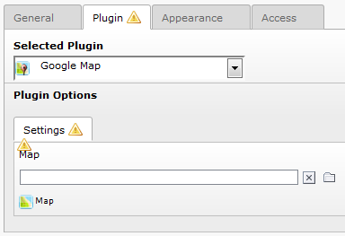
Map
One Map represents one Google Map in the frontend.
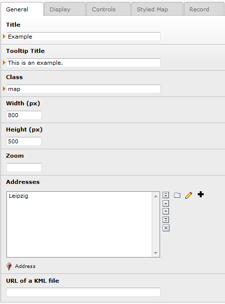
The following table shows the main configurations of a map. Each description is also shown as help text when you hover the title of a field.
Property
title
Description
Will be used as ID (without space character, special character!).
[required]
Property
width
Description
Set the width of the map. Default in px, for percentages enter ‘%’, e.g. ‘100%’.[required]
Property
height
Description
Set the width of the map. Default in px, for percentages enter ‘%’, e.g. ‘100%’.[required]
Property
zoom
Description
Only needed when the default zoom is wrong. Number between 0 and 23. 0 is the lowest zoom (whole world).
Property
zoom min
Description
The minimum zoom level which will be displayed on the map. If omitted, or set to null, the minimum zoom from the current map type is used instead.
Property
zoom max
Description
The maximum zoom level which will be displayed on the map. If omitted, or set to null, the maximum zoom from the current map type is used instead.
Property
addresses
Description
You can choose, create or edit an address. New addresses will be saved on the current page.
Property
latitude
Description
If set this latitude will be used to center the map. Otherwise the center is calculated so that all addresses fit in the map.
Property
longitude
Description
If set this longitude will be used to center the map. Otherwise the center is calculated so that all addresses fit in the map.
Property
previewImage
Description
Define an image to show as preview of the current map. Otherwise the fallback image of the TypoScript constant will be displayed if defined. If both is not set, a link will be displayed.
Property
kmlUrl
Description
Enter an URL of a KML file, e.g. http://gmaps- samples.googlecode.com/svn/trunk/ggeoxml/cta.kml
Property
kmlPreserveViewport
Description
The viewport of the kml file will be ignored. Set zoom and at least one address to configure the viewport.
Property
kmlLocal
Description
The KML file is stored on this server. The specified path (kmlUrl) is relative. Only markers appear. Search and route are only available if the KML file is local.
Property
defaultType
Description
Map type on the beginning.MAP, SATELLITE, HYBRID, TERRAIN and one individual type are possible.
Property
scrollZoom
Description
Enables zoom with scroll wheel.
Property
draggable
Description
Position of the map can be changed.
Property
doubleClickZoom
Description
A double click on the map zooms in. Draggable map has to be enabled!
Property
markerSearch
Description
Displays a form on the frontend, were the user can enter a search word. Searchs for InfoWindow content and title of a marker. The InfoWindow of the first found marker opens.
Property
showAddresses
Description
Displays a list with all addresses incl. a link. If you click the selected address will be centered.
Property
showCategories
Description
Display a checkbox for each visible category. On change the points on the map will be enabled/disabled.
Property
markerCluster
Description
Many markers in the same region will be summarized and appear as a cluster. e.g.: http://google-maps-utility-library-v3.googlecode.com/s vn/trunk/markerclusterer/examples/advanced_example.html
Property
markerClusterZoom
Description
Up to this zoom level the Clusters are displayed. Take a look at the example link above.
Property
markerClusterSize
Description
The size of the Clusters, like a radius. Take a look at the example link above.
Property
scaleControl
Description
Displays a measure.
Property
streetviewControl
Description
Shows an icon to enable the streetview.
Property
fullscreenControl
Description
Shows an icon to enable fullscreen.
Property
zoomControl
Description
Enable buttons to change the zoom.
Property
mapTypeControl
Description
Shows a control to change the map type.
Property
mapTypes
Description
Possible map types to choose. Map type control has to be enabled.MAP, SATELLITE, HYBRID, TERRAIN and one individual type are possible.
Property
showRoute
Description
2 address records needed! Shows the route between the given points
Property
calcRoute
Description
Only 1 address used as destination. Display an text input for enter a starting point.
You can configure the rendering by set the plugin.tx_gomapsext.view.layoutRoothPath, copy and edit the file Form.html.
Property
travelMode
Description
Select a travel mode or let the frontend user select one.
- Select by Frontend User (Creates a select box in the frontend. You can configure the rendering by set the plugin.tx_gomapsext.view.layoutRoothPath, copy and edit the file Form.html.)
- Bicycling (at the time only available in US)
- Driving (Default)
- Transit
- Walking.
You can configure the rendering by set the plugin.tx_gomapsext.view.layoutRoothPath, copy and edit the file Form.html.
Property
UnitSystem
Description
Select a unit system or let the frontend user select one.
- Default (No fix value)
- Select by Frontend User (Creates a select box in the frontend. You can configure the rendering by set the plugin.tx_gomapsext.view.layoutRoothPath, copy and edit the file Form.html.)
- Metric (kilometer)
- Imperial (miles).
Property
styledMapName
Description
Shown in the map type control.
Property
markerClusterStyle
Description
JSON code for the cluster style, for more information look here https://github.com/googlemaps/js-marker-clusterer
Google Maps Address
A map represents addresses and/or a KML file. An address record mainly consists of longitude, latitude and the address itself which are configured via geocoding of the configuration map.
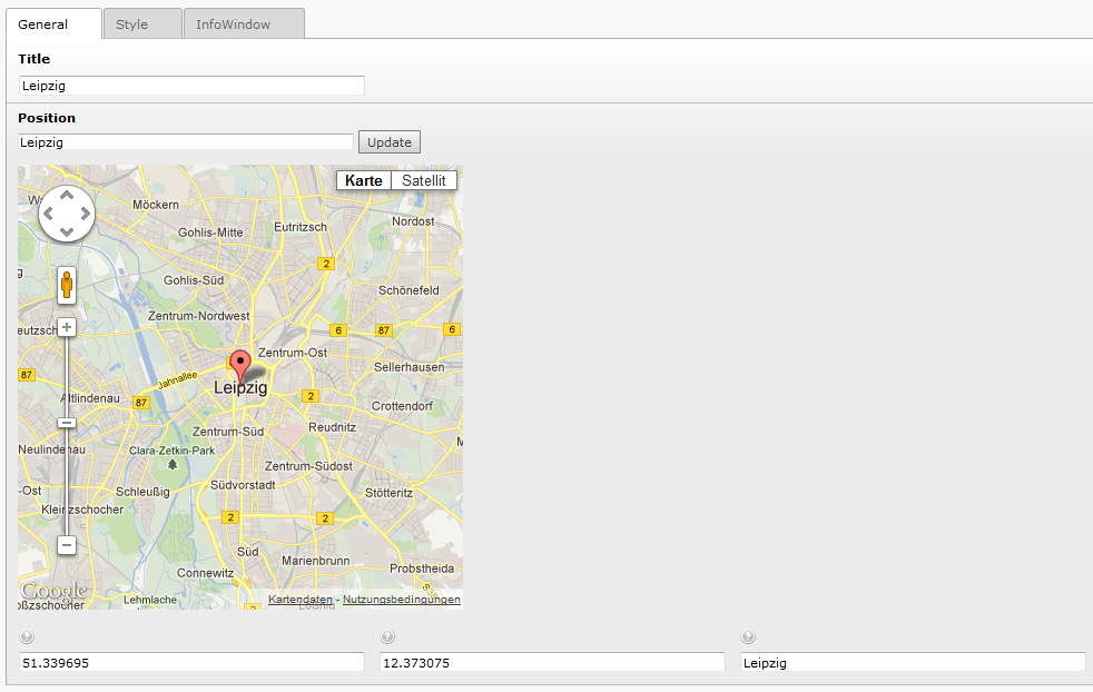
Of course there are some more options…
Property
title
Description
Only for internal usage.
[required]
Property
configurationMap
Description
Shown as Position. For geocoding the latitude, longitude and address. Enter an address [street number, zip city] or coordinates [latitude, longitude] and press ‘Update’ or drag and drop the marker in the map.
Property
latitude
Description
The latitude of the position. Configured via the position field.
[required]
Property
longitude
Description
The longitude of the position. Configured via the position field.[required]
Property
address
Description
The address of the position. Configured via the position field.[required]
Property
marker
Description
A costum image for the pin.
Property
imageSize
Description
Check if the image of the marker has a different size then default. The image should be twice as large as indicated.
Property
imageWidth
Description
Costum image width in pixel.
Property
imageHeight
Description
Costum image height in pixel.
Property
infoWindowContent
Description
This will be displayed in the InfoWindow of this marker.
Property
infoWindowImages
Description
Extra field for fal images to show in the InfoWindow.
Property
infoWindowLink
Description
Attachs an optional automatic generated link to calculate a route on Google Maps.
Property
openByClick
Description
Open InfoWindow by click instead of mouse over.
Property
closeByClick
Description
Close InfoWindow by click instead of mouse out.
Property
opened
Description
The InfoWindow is opened when the map appears. For each map there will be only one opened InfoWindow.
Property
categories
Description
Each category can be selected via GET parameters or checkboxes.