This TYPO3 extension supports the rendering of a map based on Google Maps or
OpenStreetMap. The map can be additionally enriched with markers, routes,
area and radius overlays and these overlays can be grouped into categories
for easy and recurring assignment.
Keywords
typo3,TYPO3 CMS,google maps,osm,open street map,openstreetmap,maps2
maps2 is an extension for TYPO3 CMS. It can render you a map based on Google Maps and/or OpenStreetMap. If you
want, you can create Markers, Routes, Area and Radius overlays. Assign these overlays to categories to
build a map, with all points based on selected category.
Screenshots
See maps2 in action.
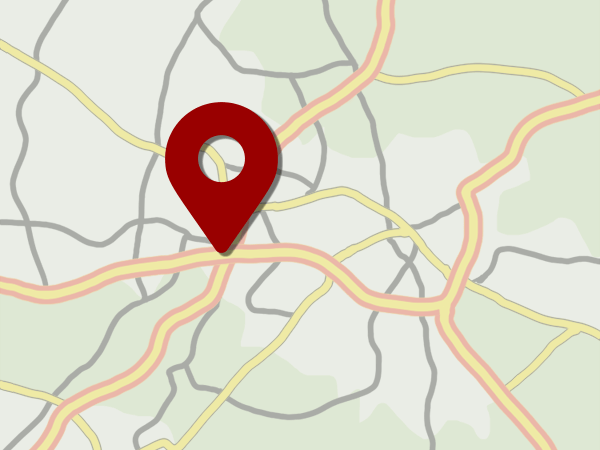
Point
Introduction Package just after installation (caption of the image)
How the Frontend of the Introduction Package looks like just after installation (legend of the image)
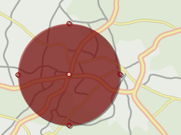
Radius
Introduction Package just after installation (caption of the image)
How the Frontend of the Introduction Package looks like just after installation (legend of the image)
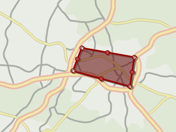
Area
Introduction Package just after installation (caption of the image)
How the Frontend of the Introduction Package looks like just after installation (legend of the image)
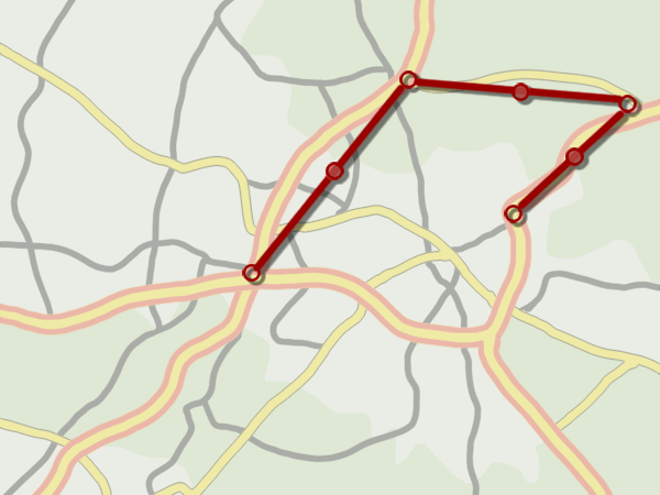
Route
Introduction Package just after installation (caption of the image)
How the Frontend of the Introduction Package looks like just after installation (legend of the image)
If your TYPO3 installation uses Composer, install the latest release of this
extension through:
composer require jweiland/maps2
Copied!
If you are not using the latest version, you need to
add a version constraint, for example:
composer require jweiland/maps2:"^9.3"
Copied!
Installing the extension prior to TYPO3 11.4
Before TYPO3 11.4 it was still necessary to manually activate extensions
installed via Composer using the Extension Manager. Activate it as follows:
Navigate to Admin Tools > Extensions > Installed Extensions
Search for maps2
Activate the extension by clicking on the Activate button in the
A/D column
Legacy mode
If you are working with a TYPO3 installation that does not use Composer, install
the extension in the Extension Manager:
Navigate to Admin Tools > Extensions > Get Extensions.
Click on Update now
Search for maps2
Click Import and install on the side of the extension entry
and activate it:
Navigate to Admin Tools > Extensions > Installed Extensions
Search for maps2
Activate the extension by clicking on the Activate button in the
A/D column
See also
On page Installing extensions
both TYPO3 installation modes are explained in detail.
Next step
Please edit ExtensionManager configuration of maps2 to decide, if you will use
Google Maps or OpenStreetMap as your default rendering service:
Configure extension.
Configuration
Minimal Example
Hint
If you want to work with Google Maps in TYPO3 backend you or an
administrator have to configure the Google Maps API keys in
Configure extension to get a working environment.
Include site set Maps2 - Default Set in "Sets for this Site" in your site.
include one of these site sets Maps2 - Google Maps or
Maps2 - Open Street Map in "Sets for this Site" in your site.
Update at least Default storage PID and JavaScript API Key settings of
maps2 in Site Settings.
Some general settings for maps2 can be configured in Admin Tools -> Settings.
The settings are divided into several tabs and described here in detail:
Tab: Basic
mapProvider
Default: both
Decide, if you want to use Google Maps or OpenStreetMap in your project.
If you're unsure you can keep both active, but in that case you and/or your
editor have the possibility to switch between Map Providers in PoiCollection
record.
Important
If you keep both active you have multiple static extension templates
available. You have to decide for one map provider in your TS-template
record. And yes, you can't show maps of both map providers on the same page.
Important
If you change from one Map Provider to another we remove the static
extension template of the prior Map Provider from selection of your
TS-template record.
defaultMapProvider
Default: gm
This setting is only relevant if you have chosen both at mapProvider. Select
a default map provider to be preselected for new poi collection records.
Important
If you keep both active you have multiple static extension templates
available. You have to decide for one map provider in your TS-template
record. And yes, you can't show maps of both map providers on the same page.
defaultMapType
Default: Point
By default an editor has to choose which type of poi collection record he wants
to create. As an administrator or integrator you have the possibility to reduce
the allowed record types. In that case it may make sense to set default map
type to another value. Further the editor saves one further click.
defaultCountry
Default: [empty]
If a Google Maps Geocode request will be requested with only a postal code, the
map provider will try to find that postal code somewhere all over the world.
If your website is only available for one specified country, you can enter
a country name to reduce the map position to given country. If you have POIs
all over the world you should keep that field empty.
defaultLatitude
Default: [empty]
By default the map in new poi collection records will be somewhere in the
atlantic at longitude:latitude 0:0. Please set default latitude to a well
known start position to start search from.
defaultLongitude
Default: [empty]
By default the map in new poi collection records will be somewhere in the
atlantic at longitude:latitude 0:0. Please set default longitude to a well
known start position to start search from.
defaultRadius
Default: 250
While creating new poi collection records of type Radius we set the default
radius to 250 meters. Change that value here, if you need another default value.
explicitAllowMapProviderRequests
Default: false
If you use our maps2 extension your browser will send requests to Google Servers
to retrieve the map images. These requests contains the IP address of the
website visitors which is a user defined information in some countries.
User defined information which will be sent to third party servers needs to be
explicit allowed by the visitor. Enable this option, if you need this explicit
activation of Google Maps in Cookie.
explicitAllowMapProviderRequestsBySessionOnly
Default: false
If you use our maps2 extension your browser will send requests to Google Servers
to retrieve the map images. These requests contains the IP address of the
website visitors which is a user defined information in some countries.
User defined information which will be sent to third party servers needs to be
explicit allowed by the visitor. Enable this option, if you need this explicit
activation of Google Maps for current browser session.
Important
Firefox stores the browser SESSION on exit by default. So this feature will
not work for Firefox browsers except you configure your firefox explicit to
destroy session vars on close.
You can define your own default template for the info window content when
clicking on a marker. Further you can override this template path again with
TypoScript:
When you're searching for an address while creating PoiCollection records maps2
starts a Geocode request to Google Maps Geocode API. If needed you can change
that URI here.
Important
There are two %s placeholders in URI. We replace them with sprintf(), so,
if you change that URI the new URI must have these two placeholders, too.
googleMapsJavaScriptApiKey
Default: [empty]
Since 2018 Google Maps needs API keys to get their services to work. So with
version 2.0.0 of maps2 you can and have to set an API key for JavaScript based
requests to Google to show the map in TYPO3 backend. Yes, this configuration is
for the backend only. To allow loading maps for frontend you should set the
same or another API key in TypoScript (see section Configuration).
Since 2018 Google Maps needs API keys to get their services to work. So with
version 2.0.0 of maps2 you can and have to set an API key for Geocoding requests
to Google to allow searching for latitude/longitude by a given address in
TYPO3 backend and frontend (Plugin CityMap).
When you're searching for an address while creating PoiCollection records maps2
starts a Geocode request to Open Street Map Geocode API. If needed you can
change that URI here.
Important
There is one %s placeholder in URI for address. We replace it with
sprintf(), so, if you change that URI the new URI must have this
placeholder, too.
Tab: Design
strokeColor
Default: #FF0000
If you work with poi collection records of type Area, Route or Radius
maps2 will use this color for borders of the overlays.
strokeOpacity
Default: 0.8
If you work with poi collection records of type Area, Route or Radius
maps2 will use this opacity to let the underlying map data shine through.
strokeWeight
Default: 2
If you work with poi collection records of type Area, Route or Radius
maps2 will use this width as border thickness for the overlays.
fillColor
Default: #FF0000
If you work with poi collection records of type Area or Radius maps2 will
fill the overlay with this color.
fillOpacity
Default: 0.35
If you work with poi collection records of type Area or Radius maps2 will
use this opacity to let the underlying map data shine through.
markerIconWidth
Default: 25
Define a default width for Marker Icons in pixel. You can override this value
individually in Category and PoiCollection records.
markerIconHeight
Default: 40
Define a default height for Marker Icons in pixel. You can override this value
individually in Category and PoiCollection records.
markerIconAnchorPosX
Default: 13
Which horizontal pixel on the image points the position on the Google Maps.
You can override this value individually in sys_category and PoiCollection
records.
markerIconAnchorPosY
Default: 40
Which vertical pixel on the image points the position on the Google Maps.
You can override this value individually in sys_category and PoiCollection
records.
Plugins
Maps2: Show map
poiCollection
Default: [empty]
Define a poi collection record which should be shown on the website.
categories
Default: [empty]
If you have not set a fixed poiCollection above you can choose one or more
categories here. If you have chosen more than one category some checkboxes will
appear below the map in frontend where you can switch the markers of the
chosen category on and off.
mapWidth
Default: 100%
The width of the map.
mapHeight
Default: 300
The height of the map.
zoom
Default: 12
Set default zoom for map in frontend.
forceZoom
Default: false
This setting is only interesting, if you will show multiple POIs on map. In
that case maps2 will zoom out until all POIs can be displayed. This is realized
with the BoundingBox feature of Google Maps or OpenStreetMap. If you don't want
maps2 to zoom out, because you have POIs all around the world for example, you
can activate this checkbox to prevent automatic zooming.
zoomControl
Default: true
Show zoom control of map provider.
activateScrollWheel
Default: true
If deactivated you can not zoom via your mouse scroll wheel over the map.
fullScreenControl
Default: true
Show control to toggle between normal and full screen mode.
Default: Road map
Map Provider: Open Street Map only
Define another external provider to show map with another layout
mapTileAttribution
Default: Road map
Map Provider: Open Street Map only
Each map needs to show the author attribution. Please check which Attribution
has to be used for defined map tile above.
Maps2: Search Radius
mapWidth
Default: 100%
The width of the map.
mapHeight
Default: 300
The height of the map.
zoom
Default: 12
Set default zoom for map in frontend.
forceZoom
Default: false
This setting is only interesting, if you will show multiple POIs on map. In that
case maps2 will zoom out until all POIs can be displayed. This is realized with
the BoundingBox feature of Google Maps or OpenStreetMap. If you don't want maps2
to zoom out, because you have POIs all around the world for example, you can
activate this checkbox to prevent automatic zooming.
zoomControl
Default: true
Show zoom control of map provider.
activateScrollWheel
Default: true
If deactivated you can not zoom via your mouse scroll wheel over the map.
fullScreenControl
Default: true
Show control to toggle between normal and full screen mode.
Default: Road map
Map Provider: Open Street Map only
Define another external provider to show map with another layout
mapTileAttribution
Default: Road map
Map Provider: Open Street Map only
Each map needs to show the author attribution. Please check which Attribution
has to be used for defined map tile above.
Maps2: City Map
autoAppend
Default: [empty]
Append a fixed string to search value. Maybe a cityname. That way the user
has only to insert a street.
mapWidth
Default: 100%
The width of the map.
mapHeight
Default: 300
The height of the map.
zoom
Default: 12
Set default zoom for map in frontend.
forceZoom
Default: false
This setting is only interesting, if you will show multiple POIs on map. In
that case maps2 will zoom out until all POIs can be displayed. This is realized
with the BoundingBox feature of Google Maps or OpenStreetMap. If you don't want
maps2 to zoom out, because you have POIs all around the world for example, you
can activate this checkbox to prevent automatic zooming.
zoomControl
Default: true
Show zoom control of map provider.
activateScrollWheel
Default: true
If deactivated you can not zoom via your mouse scroll wheel over the map.
fullScreenControl
Default: true
Show control to toggle between normal and full screen mode.
Set this value to a Storage Folder where you have stored the event records.
Important
If you have stored Organizers and Locations in another Storage Folder, you
have to add theses PIDs here, too.
Tip
If you use creation of events over frontend plugin, new records will be
stored in first PID found in storagePid. To store record in other storage
PIDs you need following configuration
Here you can define your own Fluid-Template for these little PopUps of Markers.
Since maps2 9.2.0 you have access to all related foreign records of your
PoiCollection in Template.
Use: <f:for each="{poiCollection.foreignRecords}" as="foreignRecord">...</f:for>
As such a PoiCollection can be assigned to multiple different tables like
tt_address, news, what ever, you can differ between the foreign records
with f.e.:
This value is configurable through TypoScript Constants Editor
If you work with a lot of poi collection records you can activate the marker
clusterer. The marker clusterer will merge multiple poi collections to 1 icon
with the contains amount of records.
Before any maps2 record can be shown in the frontend those need to be
created.
Create a new sysfolder.
(Of course you can also use an existing sysfolder).
Switch to List module
Use the icon in the topbar "Create new record" and search for "Maps2" and
its record "Marking".
Click on "Marking" to create a new maps2 record.
Give it a title (required)
Choose a type of record you want to create. This will reload the form to
show further fields especially for this record type. Alternative you can
click on one of these type images to switch the type.
After reload you should see some more tabs now. Click on tab "Map"
Field "Address" is required, but you can not fill it. Please use the search
field at top of map to search for an address and press <Return>. If an
address was found, we will automatically fill the required address field
in a formatted representation of the searched address.
Add a plugin to a page
A plugin is used to render a defined selection of records in the frontend.
Follow this steps to add a plugin to a page:
Maps2: Show map - Plugin
Create a new page with a title like "Location" which will be used to show
a Marking record.
Add a new content element, switch to Tab "Plugins" and select the
entry "Maps2: Show map"
Change the 1 st field to one of your created Marking records.
Save the plugin.
Here are some more possible configuration of the plugin:
If you leave marking and category field empty we will show all POIs of
configured StorageFolder
If you leave marking field empty, but select some categories we will show all
POIs of selected category. As long as they are available in configured
StorageFolder.
If marking and category field is set, marking field has precedence.
If there is a PoiCollection UID in URI this POI has precedence over marking and
category settings.
Info: If there will be shown more than one POI on the map it is not possible to
set zoom anymore. We are working with the BoundedBox feature of Google Maps
and OpenStreetMap to zoom out until all POIs are visible.
Maps2: Search Radius - Plugin
Create a new page with a title like "Radius Search" which will be used to
show a form, where a website visitor can enter an address and a range to
search for Markings.
Add a new content element of type "General Plugin"
Switch over to tab "Plugin" and select "Maps2: Search Radius" from selectbox
"Selected Plugin"
After reload go to Tab "Plugin" again and change the 1 st field to a
location where you want to search. Something like "germany" or a city name.
Save the plugin.
Maps2: City Map - Plugin
Create a new page with a title like "City Map" which will be used to show
a form, where a website visitor can enter a street name.
Add a new content element of type "General Plugin"
Switch over to tab "Plugin" and select "Maps2: City Map" from selectbox
"Selected Plugin"
After reload go to Tab "Plugin" again and Change the 1 st field to
location where you want to search. Type in a city name and the results will
be reduced to that city.
Save the plugin.
Maps2 record
The maps2 record is the most important record in this extension.
Global fields
Field
Description
Hide
Activate checkbox to hide that marker from map in frontend
Language
For which language this marker should be rendered
Type
There are currently four different types available. Choose one of Point, Radius, Area and Route
Title
Give your POI a title
Address
This field is required, but readonly. To fill it you have to search for an address in the field
at the map and press <Return>. If Google Maps or OpenStreetMap has found your address, we will
automatically fill that field with a formatted address
Map
If you are connected with the internet you should see a Map with a Marker. With a click on the map
or drag 'n drop you can move the marker on the map. If you have moved the marker the fields
latitude and longitude will be updated.
If you're working with Google Maps please set JavaScript- and GeoCoding API-Keys in ExtensionManager
Latitude
If you you know the exact latitude you can type it in here. Else you have to use the search field
to navigate to the right position
Longitude
If you you know the exact longitude you can type it in here. Else you have to use the search field
to navigate to the right position
Publish date
This is a TYPO3 field. Give it a date when your marker should be shown on the map.
Expiration date
This is a TYPO3 field. Give it a date when your marker should be hidden on the map.
Categories
This field works with the category system of TYPO3 (since TYPO3 6.0). You can assign markers to
categories. If these categories have a marker icon defined, your marker will automatically get
that marker icon assigned. A marker icon defined in your marker itself has always a higher priority.
Additional fields for Point
Field
Description
Info window content
Here you can define a text which will be displayed in a little popup, if you click on a marker in
frontend
Image(s) for info window content
Here you can define some images which should be added to the little popup.
Marker icon
If you want, you can replace maker icon with your own icon. We prefer to use a small image.
Marker icon width
If you have defined a marker icon, you should give it a fixed width here
Marker icon height
If you have defined a marker icon, you should give it a fixed height here
Marker icon position X
In case of Google Maps the lower left corner will point to the exact position on the map. With this
value you can move your icon horizontal by the amount of pixels.
In case of OpenStreetMap the center of your icon will be used to point to the exact position on
the map. If you set this value, the upper left corner will be used to move your icon horizontally.
move that position from center of icon. It
Marker icon position Y
In case of Google Maps the lower left corner will point to the exact position on the map. With this
value you can move your icon vertically by the amount of pixels.
In case of OpenStreetMap the center of your icon will be used to point to the exact position on
the map. If you set this value, the upper left corner will be used to move your icon vertically.
Additional fields for Area
Field
Description
Info window content
Here you can define a text which will be displayed in a little popup, if you click on a marker in
frontend
Image(s) for info window content
Here you can define some images which should be added to the little popup.
Stroke color
Set stroke color of the outer border. If not set we use value from Extensionmanager configuration.
Stroke opacity
Sets the border opacity. If 1 you will not see the Map behind the border. If 0 you will not see the
Border of the overlay. We prefer to set that value a little bit higher than fill opacity. If
not set we use value from Extensionmanager configuration.
Stroke weight
The width of the border in pixel. If not set we use value from Extensionmanager configuration.
Fill color
In case of Area and Radius you can choose a color to fill your marker.
If not set we get that value from Extensionmanager configuration.
Fill opacity
Sets the fill opacity. If 1 you will not see the Map behind the overlay. If 0 you will not see the
the overlay. If not set we use value from Extensionmanager configuration.
Additional fields for Route
Field
Description
Info window content
Here you can define a text which will be displayed in a little popup, if you click on a marker in
frontend
Image(s) for info window content
Here you can define some images which should be added to the little popup.
Stroke color
Set stroke color of the outer border. If not set we use value from Extensionmanager configuration.
Stroke opacity
Sets the border opacity. If 1 you will not see the Map behind the border. If 0 you will not see the
Border of the overlay. If not set we use value from Extensionmanager configuration.
Stroke weight
The width of the border in pixel. If not set we use value from Extensionmanager configuration.
Additional fields for Radius
Field
Description
Info window content
Here you can define a text which will be displayed in a little popup, if you click on a marker in
frontend
Image(s) for info window content
Here you can define some images which should be added to the little popup.
Radius
Type in the radius of your marker or resize the radius on the map to update that field.
Stroke color
Set stroke color of the outer border. If not set we use value from Extensionmanager configuration.
Stroke opacity
Sets the border opacity. If 1 you will not see the Map behind the border. If 0 you will not see the
Border of the overlay. We prefer to set that value a little bit higher than fill opacity. If
not set we use value from Extensionmanager configuration.
Stroke weight
The width of the border in pixel. If not set we use value from Extensionmanager configuration.
Fill color
In case of Area and Radius you can choose a color to fill your marker.
If not set we get that value from Extensionmanager configuration.
Fill opacity
Sets the fill opacity. If 1 you will not see the Map behind the overlay. If 0 you will not see the
the overlay. If not set we use value from Extensionmanager configuration.
Working with type "Point"
First of all search for an address.
To fine tune the position you can click somewhere on the map or drag'n drop the marker to your preferred location.
Working with type "Area"
First of all search for an address.
With left click somewhere on the map you can create new points on the map.
You need at least 3 clicks to see the fill color of the area.
Use right click to remove a point.
Route
First of all search for an address.
With left click somewhere on the map you can create new points on the map.
Use right click to remove a point.
Radius
First of all search for an address.
Click somewhere on the map or drag'n drop the center of the radius to move the marker around.
You can resize the radius via drag'n drop with one of the points at the border.
Administrator manual
This chapter describes how to manage the extension from a superuser point of view.
Since version 2.0.0 maps2 will only work with assigned Google Api Keys.
This documentation will show you step by step how to get the API Keys
from Google Clout Platform.
Google Cloud Platform
If you don't have a Google Account you have to register as a new User.
Click the button Get started which will open the `Enable Google Maps
Platform` Guide
Activate the Checkboxes for Maps and Places. Actually we don't have
support for Routes, so keep them deactivated.
Click on Continue
Open Selectbox Select or create project and
choose + Create a new project (give it a cool name) or choose one of
your previously created projects.
Click Next
If you already have assigned your billing information to your Google
Account, you now can assign them to your new project. Else you have to
create new billing information first.
Important
Google needs these billing information to be sure, that you're not a
robot. That's not a joke, that's google.
After assigning your billing information to your project, you will get the information that some
APIs have automatically activated for your project.
Click Next. It will need some seconds until all needed APIs were
activated.
You will get a Done-Message from where you can copy your new API Key and
yes: As mentioned in this dialog-box you should improve your app's security
and restrict the key's usage. If you don't do so, everyone else can use your
API Key and may generate costs over your billing information. So please:
follow the link
to API Console to
configure API security.
You will find a new entry from today with the glorious unique
name API key. Please edit this entry to assign it a better name and
configure security settings.
Give it a better Name like: Secure Map API for my project X
Set security settings to: IP-Address (Webserver, Cronjobs etc.)
and enter the IP-Address of your server. Do not activate HTTP link as
maps2 can retrieve GEO location which will never match any configured
HTTP links.
Copy your API Key and paste it into the both API fields in Extension
Configuration of maps2.
Do you want it more safe?
In the section above we told you to assign your servers IP-Address to your new
API Key, right? Ok. What happens, if you're on a shared hosting system? Every
customer on the same server can use your API Key for its own website. Hmm, bad.
Please visit
the API Console again
and create a second API Key. Give it a cool name, but that time you set security
settings to HTTP-link and assign all of your domains to this security
setting.
Copy API Key with HTTP-link to field JavaScript API Key in Extension
Configuration of maps2.
Copy API Key with IP-Address security to field Geocoding API Key in Extension
Configuration of maps2.
Configure some Budgets to prevent unwanted credits at your credit card.
Routing
EXT:maps2 does not have a list and detail view, so there is no need to
configure any route enhancers. But, it is possible to link to a POI
from foreign extensions. That is possible by defining the PoiCollection
UID as GET parameter tx_maps2_maps2[poiCollectionUid] in URI.
For this case you can use following configuration.
Hint
As PoiCollection records do NOT have any slug column defined, we really
prefer to use just the UID of the record. Please prevent the usage of
any title column as that may lead to unexpected escaping problems in URI.
If you really want to use a title please create a slug column on your own
and reference that column in aspect yourself.
If you upgrade EXT:maps2 to a newer version, please read this section carefully!
Upgrade to Version 13.0.0
This version is not compatible with TYPO3 13!
Removed static_info_tables dependency
All dependencies on static_info_tables have been removed. If you interact with
the maps2 API and provide country information, the related column in the
provided dataset must now contain an ISO 3166 alpha 2 code,
an ISO 3166 alpha 3 code, or the English country name. Integer based references
such as a static_info_tables UID are no longer supported. For further
information about country handling in TYPO3, see the
Country API
Introduction of the TCA renderType maps2Relation
With the introduction of the TCA renderType maps2Relation, integrators can
now create a TCA field as a relation to the maps2 table much more easily. Please
also refer to the revised API documentation: [link follows].
The previous implementation always created a cache file whose content changed
again after each cache clear. This caused problems during deployment. In
addition, working with objects in TCA configuration is difficult because the
TCA is not fully built at that point. TYPO3 is still in its loading state, where
various objects cannot be loaded reliably.
For these reasons, this system has been rewritten from the ground up.
Mandatory Map ID for Google Maps
Google Maps markers used for POIs have been deprecated for more than a year. To
avoid map rendering issues caused by a future removal of the old marker
implementation, maps2 now uses Google Maps AdvancedMarker. This requires an
additional Map ID in the extension configuration. If you use Google Maps, you
must configure a valid Map ID there.
Updated JavaScript Files
If you have overridden the JavaScript provided by maps2, you need to review
and reapply your custom adjustments. maps2 now uses the new Google Maps
AdvancedMarker implementation, which may require changes in customized
JavaScript files.
Upgrade to Version 12.0.0
This version is not compatible with TYPO3 12!
Updating TYPO3 extensions using class.ext_update.php has been deprecated since
TYPO3 11.0 and was removed in TYPO3 12.0. If you are upgrading from an older
maps2 version, first update to at least version 10 and execute the upgrade
wizard in the Extension Manager before proceeding.
Added Site Configuration Support
No changes or investigations are needed for integrators.
TCA Change: Restricted Record Creation to Storage Folders
With the removal of ext_tables.php and the migration to TYPO3 13
standards, the explicit permission to create POI records on standard pages
(formerly allowTableOnStandardPages) has been removed.
Following TYPO3 Core recommendations, these records are now restricted to
folders (SysFolders) by default to ensure a clean separation between
content and data records. If you need to restore the previous behavior
(allowing records on any page type), you can manually enable this in your
SitePackage's TCA override:
However, in EventListeners, PoiCollection has changed from a
QueryResult to an array.
Upgrade to Version 11.0.0
This version is not TYPO3 11 compatible!
Updating TYPO3 extensions with help of class.ext_update.php is deprecated
since TYPO3 11.0 and was removed with TYPO3 12.0. So, if you upgrade from
a very old maps2 version you should upgrade maps2 to at lease version 10.*
and execute the upgrade wizard in extensionmanager first.
Upgrade to Version 10.0.9
Somewhere in October 2023 the usage of addresses as path segment in
OpenStreetMap Geocoding URIs has been deprecated/removed. Please execute
the UpgradeWizard to activate the new parameter based OSM Geocoding URI. This
UpgradeWizard will only update that value, if it is the original old URI. Any
modified URIs will be kept untouched.
Upgrade to Version 10.0.0
We have added a new Option defaultMapType to Extension Settings of maps2.
Please check, if this value matches your needs and can be found
in LocalConfiguration.php.
Table tx_maps2_domain_model_poi has been removed. All POIs will be stored in
table tx_maps2_domain_model_poicollection now. Please execute UpgradeWizard
to migrate existing POI records.
Extension Setting and TypoScript setting allowMapTemplatePath was completely
removed. We have added a new ControllerAction called OverlayAction, so please
overwrite FluidTemplate Overlay.html instead.
All widgets are removed, as TYPO3 11 does not support ViewHelper widgets
anymore. We have moved the widget into its own Partial. Please add path to
maps2 partial as follows:
We have added a new FlashMessage queue identifier extbase.flashmessages.maps2
for non-controller FlashMessages like in GeoCodeService. Please update your
fluid templates and add both ViewHelpers:
We have changed FlexForm sheet sDEFAULT for Plugins searchwithinradius
and citymap to sDEF. Please execute UpgradeWizard to move related values
to new sheet and remove duplicates.
Only valid for developers:
As we have loaded Extbase ConfigurationManager within Middleware before TSFE it
may switch to the BackendConfigurationManager which is completely wrong. To
prevent that we have moved MapService::getMapProvider to
MapHelper:getMapProvider and deprecated MapService::getMapProvider. Please
adopt that in your extension.
JavaScript files GoogleMaps2.js and OpenStreetMap2.js have changed. Please
update your JavaScript accordingly, if you have overwritten our files.
Update to Version 9.3.4
We have moved all constructor arguments into inject-methods in
MapProviderRequestService. We have moved all constructor arguments into
inject-methods in AjaxController. So please clear all cache after update.
Please use "Flush Cache" in Installtool for TYPO3 10.* to update DI cache.
Upgrade to Version 9.0.0
As Maps2 is TYPO3 10 compatible now we have removed TYPO3 8 compatibility.
Please install an old version of maps2, if you still need TYPO3 8 compatibility.
On GitHub we have created a new Branch called TYPO3_8-7.
We have removed Maps2Registry Cache from TYPO3 CachingFramework. So you can
remove the Maps2Registry Caching Tables from DB. The cached Maps2Registry
configuration will now be saved in typo3conf/Maps2/Registry.json. In case
of Composer it will be stored in config/Maps2/Registry.json.
As a normal user you only need to clear the caches.
If you make use of the Maps2Registry API, please check, if the new json
configuration file was created. Further it would be good to check, if the
tx_maps2_uid columns still exists in DB.
Upgrade to Version 8.0.0
As a normal user you can update to this version without any problems.
We have changed the SignalSlot preIsRecordAllowedToCreatePoiCollection. It does
not allow returning $isValid as 4th parameter anymore. As $isValid is a
reference now, please change it directly and prevent your SignalSlot to return
anything.
There is no Debug Output of Map Provider response in Backend anymore, if request
fails. We have added more detailed error messages instead. As a Dev, you can
access all Messages of Client and GeoCodeService directly.
Upgrade to Version 7.0.0
As a normal user you can update to this version without any problems.
As an extension developer who has modified maps2 you should read following
lines:
We have removed ModifyMarker class.
--> Please update lat, lng and radius fields in BE form with JS directly.
We have removed modifyMarkerInDb function in our Map Provider JS files for
BE modules.
--> Please update lat, lng and radius fields in BE form with JS directly.
We have removed AjaxController.
--> As it was not used since months, it was not used anymore.
We have removed all extbase usage from all Ajax classes and have rewritten them
completely with Doctrine.
--> Please check your extension and check if an update is needed.
Update to Version 6.1.0
As mouseScrollWheelZoom is not available for all map providers you have to
execute the Update Wizard to move this Option in FlexForm from Google Maps sheet
to MapOptions sheet.
Upgrade to Version 6.0.0
The current CacheIdentifier for InfoWindowContent is not save for multilingual
environments. That way we have removed cacheIdentifier property from all Cache
ViewHelpers and added the new property poiCollection. It helps us to build a
more unique CacheIdentifier with GeneralUtility::stdAuthCode()
You have to update all of your templates where our Cache ViewHelpers are used.
In most cases only InfoWindowContent.html has to be modified. Please remove
cacheIdentifier from all Cache ViewHelpers and add poiCollection instead:
Please you are interested into Cache ViewHelper properties, please have a look
into our updated Documentation.
Update to Version 5.1.0
We have removed the hard-coded map provider settings from VH Widgets and added
these to TS-Template. So please check your maps2 output and/or individual JS,
if our Widget VHs are still working for you.
If you don't make use of our Widget ViewHelpers there should be no problem with
this update.
Upgrade to Version 5.0.0
We have added an Open Street Map Implementation. To differ between them we have
added two new static templates. One for Google Maps and one for Open Street
Map. You have to keep the Default static template, but you have to add one of
the other static templates.
There is a new Option called mapProvider in ExtensionManager. Please set the
mapProvider and default mapProvider to your needs.
We have moved some Google Maps fields in FlexForm to another sheet. To prevent
duplicates in DB please execute Update Wizard in Installtool.
We have removed automatic registering tx_maps2_uid column for tt_address. Please
take a look into the example of Maps2 Registry to see how it works.
As we have removed our API class GoogleMapsService completely you now have to
use the API methods in MapService and GeoCodeService instead.
getPositionsByAddress returns an ObjectStorage containing Position objects
instead of RadiusResult objects now. getFirstFoundPositionByAddress return an
object of type Position now.
Upgrade to Version 4.0.0
We have added some new fields to maps2. So please go into Extensionmanager
and open the configuration. Please check, if everything matches your needs and
safe the configuration.
You have to clear the system cache, because of new fields in TCA.
We have renamed the field marker_icon from table sys_category into
maps2_marker_icons and switched to FAL related images. Please execute Update
script in Extensionmanager for maps2 to migrate your old images.
We have moved all JavaScript Code from page.includeJSFooter to
page.includeJSFooterlibs, so now you have better options to override or
append our/your custom JavaScript in TypoScript.
All methods of MapService have been migrated into GoogleMapsService.
GeocodeUtility have been deleted. Please use getPositionsByAddress or
getFirstFoundPositionByAddress of GoogleMapsService.
Upgrade to Version 3.0.0
We have removed TYPO3 6.2 compatibility completely.
In f.e. germany it is not allowed to send the users ip address without
his confirmation. That's why we have added a new extension management
configuration which can output a little form, where the user can accept sending
his information to third party servers like Google to display the maps. This
new feature touches nearly all methods, so, if you have extended maps2, please
pre-check the new widget templates and actions. Maybe it's good to have a look
into the new GoogleMapsService class.
Update to Version 2.5.0
With version 2.5.0 we have solved a camelcase problem of the cache table.
It was renamed from cf_maps2_cachedHtml to cf_maps2_cachedhtml. Please delete
the old tables cf_maps2_cachedHtml and cf_maps2_cachedHtml_tags, deactivate
maps2 in extension manager and activate it again.
Important
It does not help to rename these tables only.
Upgrade to Version 2.0.0
Version 2.0.0 needs a Google Maps JavaScript ApiKey which has to be inserted in
maps2 configuration of Extensionmanager (for BE usage) and in constants section
of your TypoScript-Template (for FE usage). That's why you have to insert the
static template Maps2 (maps2) in your TypoScript Template now.
Furthermore we have updated the FlexForm of maps2 and removed the option for
SwitchableControllerActions. With version 2.1.2 we have added an Update-Wizard
in Extensionmanager which can do that job for you. In prior versions you have to
remove that setting of each plugin in tt_content record field pi_flexform on
your own.
Important
It does not help to open and save the record in backend!
EXT:maps2 is using fluid as template engine. If you are know how to manage fluid
templates, you can skip this section.
Changing paths of the template
You should never edit the original templates of an extension as those changes
will vanish if you upgrade the extension. As any extbase based extension, you
can find the templates in the directory Resources/Private/.
If you want to change a template, copy the desired files to the directory where
you store the templates. This should be a directory in your SitePackage
extension. Multiple fallbacks can be defined which makes it far easier to
customize the templates.
ViewHelpers are used to add logic inside the view.
There're basic things like if/else conditions, loops and so on. The system
extension fluid has the most important ViewHelpers already included.
To be able to use a ViewHelper in your template, you need to follow always the
same structure which is:
<f:foo>bar</f:foo>
Copied!
This would call the ViewHelper foo of the namespace f which stands for
fluid. If you want to use ViewHelpers from other extensions you need to add the
namespace declaration at the beginning of the template. Add or update following
lines in your template, partial or layout:
Now you can use a ViewHelper of maps2 with a code like:
<maps2:trimExplode><!-- some comment --></maps2:trimExplode>
Copied!
If you want to know what a ViewHelper does, it is very easy to find the related
PHP class by looking at the namespace and the name of the ViewHelper. Having
e.g. JWeiland\Maps2\ViewHelpers and convertToJson you will find the
class at maps2\Classes\ViewHelpers\ConvertToJsonViewHelper.php.
The most awesome thing is that you can use ViewHelpers of any extension in any
other template by just adding another namespace declaration like:
Use this ViewHelper to check user consent, if requests to map providers like
Google Maps or OpenStreetMap are allowed or not.
Examples
Basic example
<f:ifcondition="{m:isRequestToMapProviderAllowed()}"><f:then>
...do something to show the map or what ever you want...
</f:then><f:else>
...show overlay or add a message what user should do to see the map...
</f:else></f:if>
Copied!
RequestUriForOverlayViewHelper
This ViewHelper creates an URI with a special parameter which allows the map to
be visible for the user.
Examples
Basic example
<ahref="{m:requestUriForOverlay()}">
Link to current page. Map will be shown somewhere on that page.
</a>
Copied!
Scroll to content element
If you add ttContentUid to ViewHelper it will add a link section (#174)
to the end of the URI. If all of your content elements contain an id attribute
like c174 the target page will scroll to this specific content element
directly.
<ahref="{m:requestUriForOverlay(ttContentUid: ttContentUid)}">
Link to current page and scroll to content element with map.
</a>
Copied!
TrimExplodeViewHelper
This is a ViewHelper to convert a comma separated value into an array.
All values will be trimmed.
If you want you can define a prefix for the generated CacheIdentifier. Leave
this value empty to use "infoWindow" as default value
poiCollection
poiCollection
Type
PoiCollection
Required
true
You must assign the PoiCollection object to this ViewHelper. We extract some
data from PoiCollection to build a more unique CacheIdentifier which can differ
Caches in multilingual environment.
data
data
Type
string
Required
true
The data as string which has to be stored.
tags
tags
Type
array
You can define some additional CacheEntryTags if you want. By default we add
two additional Cache Tags named infoWindowUid{PoiCollectionUid} and
infoWindowPid{PoiCollectionPid}
lifetime
lifetime
Type
int
How long (in seconds) the CacheEntry should be available, before it will be
re-generated? Keep this value empty to use the Default Value of Storage-Backend.
0 for unlimited.
Maps2 comes with some public methods which we have marked with @api. Use
them to simplify your life within your extensions when working with maps2.
GeoCodeService
getFirstFoundPositionByAddress
Give it an address (string) as first argument and you will get first found
address as Position object. If the geocoding service has nothing found or an
error occurs this method will return null. There is no need to
:php:rawurlencode the address as we will do it for you.
getPositionsByAddress
Give it an address (string) as first argument and you will get all found results
from geocoding service as Position object in an ObjectStorage.
MapService
createNewPoiCollection
Use it, if you have some location records in your extension and want to create
a new PoiCollection relation automatically while saving your location record.
assignPoiCollectionToForeignRecord
We have over 5 extensions working together with maps2 and we always have to
implement a part to save the PoiCollection UID to our other extensions. Wouldn't
it be better to have a centralized method doing that?
addForeignRecordsToPoiCollection
This method is NOT public API. It will be called automatically, if you call
getForeignRecords of a PoiCollection. It contains a SignalSlot where you can
remove or modify foreignRecords before adding them to PoiCollection.
Example
Here we have a working example out of our extension events2:
// create new map-record and set it in relation
$position = $this->googleMapsService->getFirstFoundPositionByAddress($this->getAddress($eventLocation));
if ($position instanceof Position) {
    $tsConfig = $this->getTsConfig($eventLocation);
    $this->googleMapsService->assignPoiCollectionToForeignRecord(
        $this->googleMapsService->createNewPoiCollection(
            (int)$tsConfig['pid'],
            $position,
            array(
                'title' => $eventLocation['location']
            )
        ),
        $eventLocation,
        'tx_events2_domain_model_location',
        'tx_maps2_uid'
    );
}
Copied!
MapRegistry
getColumnRegistry
Get the Maps2 registry as ColumnRegistrationStorage object for all
tables, columns and its configuration.
We have added a service maps2.columnRegistry to Services.yaml which you can
use for your extensions:
This is a pretty cool feature to extend your own extension with a new field
which will hold the reference UID to a PoiCollection record of maps2. So, if
you have a location record or something similar, then you can use our Maps2
registry to create a new field into a table of your extension.
Create a new file in [yourExt]/Configuration/TCA/Overrides/[yourTableName].php
and add the needed lines of code. Keep an eye on the new renderTypemaps2Relation which is available since maps2 13.0.0:
The maps2 registry will automatically be filled with every column identified
by this new renderType.
Basic Example
To help geocoding service you have to provide some address related columns
of your table. Would be good to enter the address columns in an official
order of the address form:
To prevent geocoding service to search for your addresses all over the world
you should provide a country. If you have a country column in your table
please provide it that way:
If you also add the country column to addressColumns it will automatically
removed internally.
Of cause you still can make use of defaultCountry as a fallback.
Matching Columns
By default maps2 will try to assign a poi collection record to every
of your registered tables. But if you have a lot of records or you want to
reduce possible cost you may want to reduce the amount of records to a specific
storage record or another value of your records:
<?phpuseTYPO3\CMS\Core\Utility\ExtensionManagementUtility;
ExtensionManagementUtility::addTCAcolumns(
'tt_address',
[
'tx_maps2_uid' => [
'config' => [
'type' => 'group',
'renderType' => 'maps2Relation',
'addressColumns' => [
'address',
'zip',
'city',
],
'columnMatch' => [
// Simple match'pid' => '12',
'title' => 'jweiland.net',
// More complex examples:// Same as above: equals'pid' => [
'expr' => 'eq',
'value' => '12',
]
// pid is in list of comma separated values'pid' => [
'expr' => 'in',
'value' => '11,12,13',
]
// pid is greater than 8'pid' => [
'expr' => 'gt',
'value' => '8',
]
// pid is greater than or equals 12'pid' => [
'expr' => 'gte',
'value' => '12',
]
// pid is less than 15'pid' => [
'expr' => 'lt',
'value' => '15',
]
// pid is less than or equals 12'pid' => [
'expr' => 'lte',
'value' => '12',
]
],
],
],
],
);
// Label with "Google Maps"
ExtensionManagementUtility::addToAllTCAtypes(
'tt_address',
'--div--;maps2.db:tab.maps2.gm,tx_maps2_uid',
);
Copied!
Simple Default Storage
By default maps2 will store the related POI collection record on the same
storage folder as of your stored record. If you want maps2 to store
poi collection record in a different storage folder you can set a hard-coded
default storage PID:
By default maps2 will store the related POI collection record on the same
storage folder as of your stored record. If you want maps2 to store
poi collection record in a declared storage PID defined in on of the installed
extensions you can configure it that way:
By default maps2 will store the related POI collection record on the same
storage folder as of your stored record. If you want maps2 to store
poi collection record in a declared storage PID defined by a value of
PageTS config ext.my_ext.specialConfiguredPidForMaps2 = 4324
By default maps2 will store the related POI collection record on the same
storage folder as of your stored record. If you want maps2 to store
POI collection record in a different storage folder you can set various
ordered storage PID locations:
By default maps2 will only add the related UID of POI collection to your record
but it is possible to synchronize further columns like a title od a hidden flag.
Following example shows how to synchronize location column of your table into
the title column of maps2 POI collection record:
You can add multiple configuration to synchronizeColumns. BUT: Currently,
only 1:1 relations are allowed.
Override Configuration
The Maps2Registry is an API, so other extension may make use of it and have
already created a relation for their tables. But you as a developer need a tool
to always override the maps2 registry to your needs.
That's why we have implemented an override feature:
This will remove the registration of the other extensions/developers and just
yours will win.
Change maps2 tab to "OpenStreetMap"
In the examples above you only see how to create a new tab for
Google Maps to TCEforms in backend, but it is also possible to change that to
OpenStreetMap:
// Label with "OpenStreetMap"
ExtensionManagementUtility::addToAllTCAtypes(
'tt_address',
'--div--;maps2.db:tab.maps2.osm,tx_maps2_uid',
);
Template
With EXT:maps2 version 10.0.0 we have remove PoiCollection- and
EditPoiCollection ViewHelper. This part will explain how to change your
template to use the new implementation.
PoiCollection
Add static TS template Maps2 Default (maps2) and one of
the Maps2 for Google Maps (maps2) or Maps2 for Open Street Map (maps2)
templates to the page where your extension/plugin belongs to, as far as not
already done in root page.
In case of Maps2 for Google Maps (maps2)please check, if following
TS constant is set:
plugin.tx_maps2.view.googleMapsJavaScriptApiKey
Copied!
Add a further entry for maps2 to partialRootPaths configuration of your
extension, so that fluid can find our new partials:
Add static TS template Maps2 Default (maps2) and one of the
Maps2 for Google Maps (maps2) or Maps2 for Open Street Map (maps2) templates
to the page where your extension/plugin belongs to, as far as not already done
in root page.
In case of Maps2 for Google Maps (maps2)please check, if following
TS constant is set:
plugin.tx_maps2.view.googleMapsJavaScriptApiKey
Copied!
Add a further entry for maps2 to partialRootPaths configuration of your
extension, so that fluid can find our new partials:
In most cases EXT:maps2 uses the QueryBuilder to query data, but in case of
Plugin maps2_searchwithinradius we need to execute a native MySQL query
without QueryBuilder to find the related POIs. In that special case
MySQL/MariaDB is mandatory.
Consent Tools
If you want to use external consent tools you should deactivate both options
explicitAllowMapProviderRequests and
explicitAllowMapProviderRequestsBySessionOnly in extension manager.
Klaro
Overwrite Templates path with help of TypoScript and copy
Templates/PoiCollection/Show.html into your SitePackage extension. Add
data-name attribute to existing div-tag.
In some cases it may happen, that the map will be displayed partly. To prevent
that problem a reload after accepting the consent may help. Create a new JS
file which will be loaded AFTER klaro.js. Keep the name of data-name,
in this case maps2 here, too: