Administratormanual
Target group: Administrators
Installation
Import the extension from TER (TYPO3 Extension Repository) like any other extension.
On a page 'feusersmap' or on your root page insert 'Typoscript Include static' (from extension) FeUsersMap (feusersmap). With the constant editor insert the desired settings of the extension like storage Pid, your page ID's, jQuery options, path to templates etc.
On page 'feusersmap' insert the plugin map and set the plugin options. Insert some custom groups for the filter.
Feusersmap plugin options
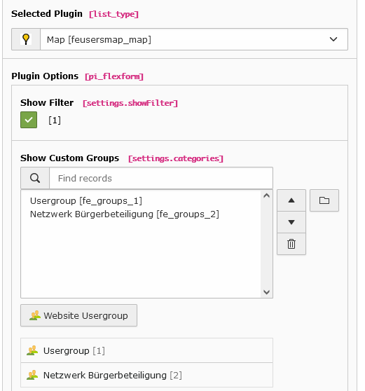
The data of fe_users and fe_groups is stored in Frontend Users. Insert in the constant editor the correct "Default storage PID" of the fe_users records.
Then insert at least one fe_group. The extension tries to fetch the coordinates by itself like the mymap extension. But https://nominatim.openstreetmap.org did not allow bulk requests for geocoding. So best is to get the coordinates for the fe_user on other way.
To use your own mapIcons insert your mapIcons into the directory fileadmin/ext/feusersmap/Resources/Public/Icons. Insert in this directory your icons which then can be selected in your fe_groups data records.
When everything is ok - test it...
Inserting data
In TYPO3 list module select the page of of general storage pid. First insert some usergroups. Then you can insert some fe_users. If the field mapgeocode is set, the extension tries to get the coordinates. If that fails, the field mapgeocode is set to 0. If you don't insert some mapicon, the extension uses a default icon for the marker.
When everything is done you can start a search in frontend.
Reference
plugin.tx_feusersmap
templateRootPath
Property
templateRootPath
Data type
string
Description
path to templates
Default
EXT:feusersmap/Resources/Private/Templates/
partialRootPath
Property
partialRootPath
Data type
string
Description
path to partials
Default
EXT:feusersmap/Resources/Private/Partials/
layoutRootPath
Property
layoutRootPath
Data type
string
Description
path to layouts
Default
EXT:feusersmap/Resources/Private/Layouts/
includejQueryCore
Property
includejQueryCore
Data type
int
Description
include the jQuery library of myleaflet
Default
0
plugin.tx_feusersmap.settings
detailsPageId
Property
detailsPageId
Data type
int
Description
Id of the details page
Default
initialMapCoordinates
Property
initialMapCoordintes
Data type
string
Description
Initial map coordinates [latitude,longitude]
Default
48,8
searchAddress
Property
searchAddress
Data type
string
Description
Initial search address
Default
Köln
searchRadius
Property
searchRadius
Data type
int
Description
Initial search radius
Default
300
useGroupLeafletmapicons
Property
useGroupLeafletmapicons
Data type
boolean
Description
If set, enables the clustering of locations
Default
1
enableMarkerClusterer
Property
enableMarkerClusterer
Data type
boolean
Description
If set, enables the clustering of locations
Default
0
markerIconWidth
Property
markerIconWidth
Data type
int
Description
The width of the marker icon
Default
12
markerIconHeight
Property
markerIconHeight
Data type
int
Description
The height of the marker icon
Default
20
Known problems
No map loaded - ReferenceError: $ is not defined
Make sure, you have loaded the jQuery on top of the page. This can be done with the constant editor of TYPO3 and the feusersmap category (plugin.tx_feusersmap.view.includejQueryCore).
FAQ
Custom templates and files
You can use your own template and CSS file or other jQuery library - just go to the TYPO3 constants editor and change the values for your needs.