Administratormanual
Target group: Administrators
Installation
Import the extension from TER (TYPO3 Extension Repository) like any other extension. Create some pages as shown below.
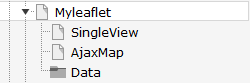
On page 'Ajax Map' install plugin MyLeaflet (Map). Make sure you have installed jQuery on top of the page.
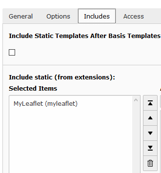
On page 'myleaflet' or on your root page insert 'Typoscript Include static' (from extension) MyLeaflet (myleaflet). With the constant editor insert the desired settings of the extension like storage Pid, your page ID's, jQuery options, path to templates etc.
The data of tt_address and sys_categories is stored in page Data. Insert in the constant editor the correct "Default storage PID" of the tt_address records.
Then insert at least one sys_category in the page Data. Now insert some tt_address data records with latitude and longitude values and assign them to sys_categories. The extension did not fetch the coordinates by itself like the mymap extension.
To use your own mapIcons insert your mapIcons into the directory fileadmin/ext/myleaflet/Resources/Public/Icons. Insert in this directory your icons which then can be selected in your tt_address data records.
When everything is ok - test it...
Inserting data
In TYPO3 list module select page Data. First insert some sys_categories. Then you can insert some tt_address data records. You have to insert the coordinates. If you don't insert some icon, the extension uses a default icon for the POI's.
When everything is done you can start a search in frontend.
Reference
plugin.tx_myleaflet.view
templateRootPath
- Property
- templateRootPath
- Data type
- string
- Description
- path to templates
- Default
- EXT:myleaflet/Resources/Private/Templates/
partialRootPath
- Property
- partialRootPath
- Data type
- string
- Description
- path to partials
- Default
- EXT:myleaflet/Resources/Private/Partials/
layoutRootPath
- Property
- layoutRootPath
- Data type
- string
- Description
- path to layouts
- Default
- EXT:myleaflet/Resources/Private/Layouts/
includejQueryCore
- Property
- includejQueryCore
- Data type
- int
- Description
- include the jQuery library of myleaflet
- Default
- 0
plugin.tx_myleaflet.settings
detailsPageId
- Property
- detailsPageId
- Data type
- int
- Description
- Id of the details page
- Default
-
singleViewUid
- Property
- singleViewUid
- Data type
- int
- Description
- Uid of the location record to be shown with the single view plugin.
- Default
- 1
resultLimit
- Property
- resultLimit
- Data type
- int
- Description
- Limit the result to n records
- Default
- 300
initialMapCoordinates
- Property
- initialMapCoordintes
- Data type
- string
- Description
- Initial map coordinates [latitude,longitude]
- Default
- 48,8
categorySelectMode
- Property
- categorySelectMode
- Data type
- string
- Description
- The mode of selection of categories [AND|OR]
- Default
- OR
enableMarkerClusterer
- Property
- enableMarkerClusterer
- Data type
- boolean
- Description
- If set, enables the clustering of locations
- Default
- 0
defaultLanguageUid
- Property
- defaultLanguageUid
- Data type
- string
- Description
- Use 0 in multi language sites to override selected language in Frontend and if tt_address record are not localized. Leave it blank to use TYPO3 localization.
Default
markerIconWidth
- Property
- markerIconWidth
- Data type
- int
- Description
- The width of the marker icon
- Default
- 12
markerIconHeight
- Property
- markerIconHeight
- Data type
- int
- Description
- The height of the marker icon
- Default
- 20
Known problems
No images are shown - if you use the fluid <f:image …> tag in the templates, make sure you have set a one level Slug.
No map loaded - ReferenceError: $ is not defined
Make sure, you have loaded the jQuery on top of the page. This can be done with the constant editor of TYPO3 and the myleaflet category (plugin.tx_myleaflet.view.includejQueryCore).
FAQ
Custom templates and files
You can use your own template and CSS file or other jQuery library - just go to the TYPO3 constants editor and change the values for your needs.