Single View
In this view, we have to deal with two problems:
- Positioning correctly the fields,
- Executing a plugin from the maps2 extenstion.
Positioning the Fields
The positioning of the fields is very simple in the List view
because you can define the template. For the Single and Edit
views, the positioning can be obtained using the
wrapItem property.
This property has the same syntax and the same behaviour as the wrap
property in TypoScript.
To perform the requested positioning, we will use <div> tags organized as follows:
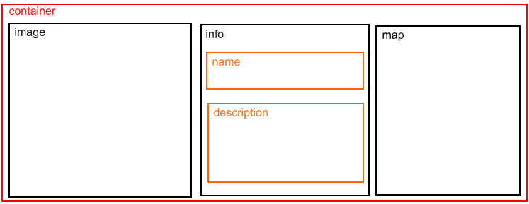
The wrapping is done field by field. For example, the first field is
image. It defines the beginning of the container <div> and the image
<div> when the following property is used:
wrapItem = <div class="container"><div class="image"> | </div>;
- Analyze the wrapItem
for all the fields, then open the file
sav_library_example10.cssin theResources/Public/Cssdirectory to analyze the configuration. As it can be seen, the labels associated with the field are not displayed thanks to the {display:none;} CSS configuration. Let us note that the same result could have been obtained using the cutLabel property in the Kickstarter (see for example theimageandmapfields).
Executing the Plugin
Executing a plugin in the extension can simply be done by means of the
tsObject and
tsProperties properties.
The tsObject is a content
object in TypoScript, that is TEXT, FILE, CONTENT, … Below is the configuration
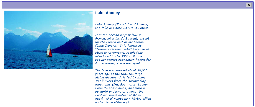
of the field map.
tsObject = USER;
The USER is used to execute the action show of the plugin Maps2.
The extension settings are iported and modified. Let us note the use of
the marker ###poi_uid### which provides the uid of the point of interest for
the map.
tsProperties =
   userFunc = TYPO3\CMS\Extbase\Core\Bootstrap->run
   extensionName = Maps2
   pluginName = Maps2
   vendorName = JWeiland
   action = show

   switchableControllerActions {
      PoiCollection {
         1 = show
      }
   }

   settings < plugin.tx_maps2.settings
   settings {
      zoom = 18
      poiCollection = ###poi_uid###
      category =
      mapWidth = 100%
      mapHeight = 300
   }
}
;
showIf = 0 < ###poi_uid###;
The showIf property checks
if the marker ###poi_uid### is positive. If true the map is displayed,
otherwise it is cut as shown below.
Let us now explain how the marker ###poi_uid### is set. Let us
have a look to the configuration of the field poi_uid whose type
is Show Only.
The first configuration is to always cut the field, i.e. it will not be displayed because it is is just a working field.
cutIf = true;
The second configuration gets the uid by means of a CONTENT object.
The marker ###uidMainTable### is always available. It is replaced by the
uid of the current field in the main table.
tsObject = CONTENT;
tsProperties =
   table = tx_maps2_domain_model_poicollection
   select {
      join = tx_savlibraryexample10_poi_mm ON tx_maps2_domain_model_poicollection.uid = tx_savlibraryexample10_poi_mm.uid_foreign
      selectFields = tx_maps2_domain_model_poicollection.uid
      where = uid_local = ###uidMainTable###
   }
renderObj = TEXT
renderObj.field = uid
;
The third configuration sets the field value in the marker poi_uid, i.e.
the marker ###poi_uid### is now available.
renderFieldInMarker = poi_uid;